A Caterpillar 336 excavator with a 6-meter reach bucket often marks the starting point of a deep excavation in Guelph, but the real work begins long before the boom swings. The city sits on a complex stratigraphy of Port Stanley Till overlying fractured Guelph Formation dolostone, a geological contrast that demands rigorous pre-construction analysis. Shoring design here is not a generic exercise—it must account for dense silt-clay matrices that stand near-vertically when dry yet lose cohesion rapidly once the water table fluctuates. The speed of the Speed River's tributary recharge and seasonal perched groundwater in the till layer create conditions where an unsupported cut can degrade within hours. We integrate site-specific parameters into finite element models to quantify deformation before any bucket touches the ground. When borehole data reveals soft pockets within the till, the shoring system often needs to be combined with a grouting program to stabilize the face, and in overconsolidated zones near the escarpment, we assess whether anchors can be installed without risk of bond failure in fractured bedrock.
Guelph's Port Stanley Till stands nearly vertical when dry, but pore pressure lag after excavation can transform it into a flowing mass within hours.
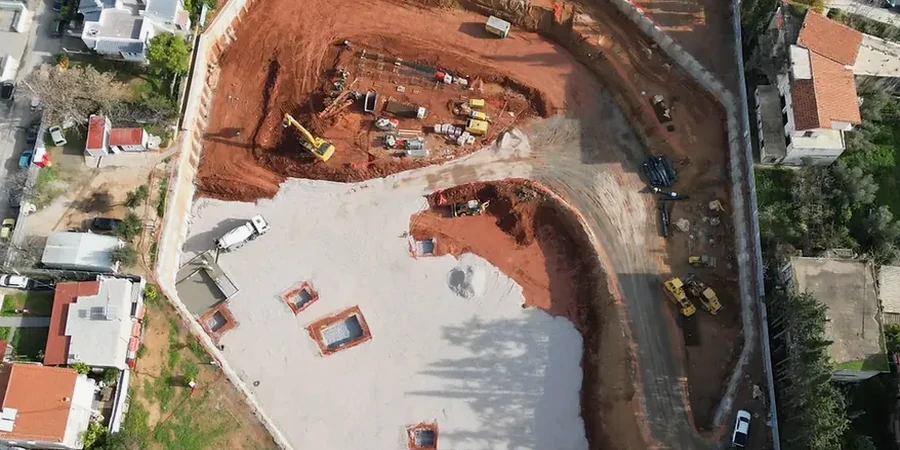
Scope of work in Guelph
Demonstration video
Local geotechnical conditions in Guelph
Guelph's population surpassed 144,000 in the 2021 census, and the pressure to densify the downtown core has pushed excavation depths past 12 meters in recent mixed-use projects. A critical risk that emerges at these depths in the local till is time-dependent lateral deformation: the Port Stanley Till exhibits low hydraulic conductivity (often in the range of 10⁻⁷ to 10⁻⁸ cm/s), meaning pore pressure dissipation lags significantly behind excavation advance. This creates a window where effective stress remains low and the soil mass behaves as if undrained, elevating the risk of a basal instability. A second concern is the proximity of heritage limestone structures in the older wards, where vibration from sheet pile driving or excessive wall deflection can trigger settlement claims. Our risk mitigation strategy combines inclinometer monitoring at multiple depths with real-time pore pressure transducers, allowing the contractor to adjust the excavation rate before deflection thresholds are reached. In areas adjacent to the Speed River, we also account for the potential of rapid groundwater inflow through karstic conduits in the dolostone, a feature well-documented in the Guelph region's hydrogeological literature.
Our services
Deep excavation design in Guelph requires more than selecting a shoring system from a catalogue. The work spans from initial site characterization through construction-phase monitoring, with each stage calibrated to the local till-bedrock transition. Below are the core services we provide for excavation projects across the city.
Shoring System Design & Analysis
We develop excavation support plans using limit equilibrium and numerical modeling (PLAXIS, WALLAP). Designs address the full depth of the Port Stanley Till and its interaction with the Guelph Formation dolostone, including cantilever, anchored, and braced wall configurations. Each design package includes deflection predictions, structural sizing, and construction sequence recommendations compliant with NBCC and CSA A23.3.
Groundwater Control & Depressurization Planning
Given the perched water table in Guelph's till and the potential for karstic inflow from the underlying dolostone, we design dewatering and depressurization systems that prevent base instability. Our approach combines pumping test analysis with 3D seepage modeling to specify well spacing, depth, and discharge rates that maintain a dry excavation without triggering settlement in adjacent structures.
Frequently asked questions
How does the Guelph Formation dolostone affect deep excavation design?
The dolostone bedrock in Guelph is moderately strong but often contains solution-widened joints and karst features that channel groundwater unpredictably. When the excavation base approaches the rock surface, we must assess potential for hydrofracturing of the till-rock contact and design either a socketed wall or a grout curtain to cut off inflow. The rock's RQD can vary from 60% to below 30% across short distances, so we rely on closely spaced boreholes to map the variability.
What are the typical shoring options for a 10-meter excavation in downtown Guelph?
For a 10-meter cut in the dense Port Stanley Till, soldier piles with two or three levels of pre-stressed tieback anchors are often the most economical choice. Where adjacent buildings limit tieback easements, we shift to internally braced systems or secant pile walls. The final selection depends on the till's undrained shear strength profile and the proximity of bedrock—if rock is within 2 meters of the base, socketed soldier piles can reduce basal heave risk significantly.
How do you monitor lateral wall movement during excavation?
We specify inclinometer casings installed behind the shoring wall, typically extending at least 3 meters below the excavation base into competent till or rock. Readings are taken at each excavation stage and compared against the predicted deflection envelope. If movement exceeds 80% of the design threshold, we recommend contingency measures such as installing additional tiebacks or reducing the unsupported span before the next lift. Automated total station monitoring of surrounding buildings runs in parallel.