Guelph sits at roughly 334 meters above sea level, built on a complex legacy of glacial till, outwash, and the underlying Guelph Formation dolostone. This geology creates soil profiles where a single layer might contain everything from gravel-sized fragments to microscopic clay particles — a reality that makes grain size analysis (sieve + hydrometer) a non-negotiable step before any serious earthwork or foundation design. The unified classification of a soil, its permeability, frost susceptibility, and even its compaction behavior all hinge on knowing the exact particle distribution curve. Our laboratory in the region runs the full ASTM D422 procedure, combining mechanical sieving for the coarse fraction with a hydrometer sedimentation test for fines passing the No. 200 sieve. For projects near the Speed River or in the newer subdivisions east of the Hanlon Parkway, atterberg limits become the logical companion test to define the plasticity of those silty clays that the hydrometer reveals, giving you a complete picture of the soil’s engineering personality.
A soil isn't sand or clay until the hydrometer says so — and in Guelph’s glacial geology, it’s usually both.
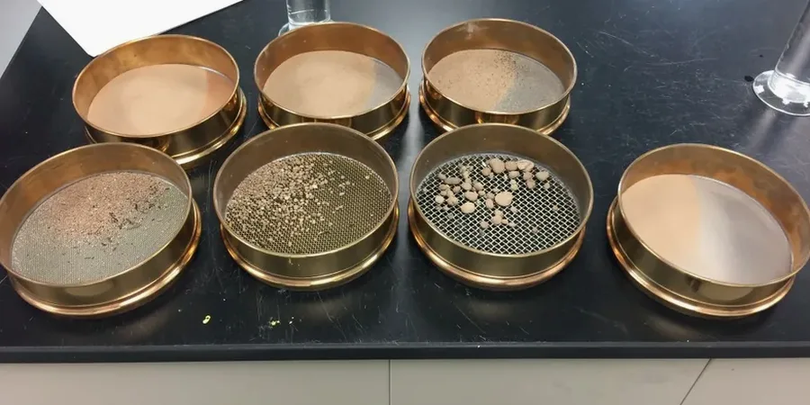
Scope of work in Guelph
- Sieve stack from 75 mm down to 75 µm (No. 200) covering coarse gravel to fine sand.
- Hydrometer analysis per ASTM D422 for silt and clay fractions below 75 µm.
- Full gradation curve with D10, D30, D60, and uniformity/curvature coefficients calculated.
Local geotechnical conditions in Guelph
The Ontario Building Code (OBC) references the National Building Code of Canada, which requires soil classification per ASTM D2487 (USCS) for foundation design — and that classification is directly determined by grain size analysis. In Guelph, the risk goes beyond code compliance. Much of the city’s subsurface includes glaciolacustrine silts and clays that are borderline frost-susceptible (F4 soils under the MTO classification). A grain size curve showing more than 10% passing the 20 µm sieve puts a soil into frost-susceptible territory, which changes pavement structure design entirely. Add to this the presence of soft, compressible clay pockets in the Guelph moraine deposits, and a missing hydrometer test can cascade into differential settlement, frost heave under parking lots, or drainage failures around underground utilities. Developers relying on visual classification alone consistently underestimate the fines content of these tills by 15 to 30 percentage points — a margin that can flip a soil from SM (silty sand) to SC (clayey sand) and invalidate the bearing capacity assumption.
Our services
A complete particle size distribution test in Guelph is rarely a standalone request. Most projects benefit from pairing the gradation curve with complementary testing to build a defensible geotechnical model.
Full Sieve + Hydrometer Package
The core grain size analysis covering everything from gravel down to the 0.2 µm clay fraction. Includes oven-dried preparation, mechanical sieve shaking, hydrometer sedimentation readings at 0.5, 1, 2, 4, 8, 15, 30, 60, 120, and 1440 minutes, and a final report with the complete particle size distribution curve, Cu/Cc coefficients, and USCS group symbol. You get the data needed for foundation bearing capacity, pavement subgrade rating, and drainage media specification.
Correlated Index Testing
Pair the gradation curve with Atterberg limits (liquid limit, plastic limit, plasticity index) to definitively classify fine-grained soils as ML, CL, MH, or CH per USCS. For fill quality control, we add a modified Proctor (ASTM D1557) to establish the moisture-density relationship on the same material. A combined report gives your structural engineer the complete mechanical characterization needed for Guelph’s typical spread footing and slab-on-grade designs.
Frequently asked questions
How much does a grain size analysis (sieve + hydrometer) cost in Guelph?
How long does the hydrometer test take compared to the sieve analysis?
The sieve portion is relatively quick — washing, drying, and shaking can be done in one working day. The hydrometer analysis requires a minimum of 24 hours of sedimentation readings, and for soils with significant clay content in Guelph’s glacial deposits, we often extend readings to 48 hours to capture the full fine fraction below 2 µm. A complete sieve + hydrometer report is typically delivered in 3 to 5 business days.
What sample size do I need to send for a grain size test?
For soils with particles up to 4.75 mm (No. 4 sieve), a 500 g representative sample is sufficient. If your Guelph till contains gravel up to 75 mm — common in the moraine deposits — we need between 10 and 20 kg of material to run the full coarse sieve stack accurately. We provide sampling bags and guidance on how to take a representative disturbed sample from your test pit or borehole.
Why can’t I just use a visual classification instead of running the hydrometer?
Visual classification routinely underestimates fines content by 15 to 30 percentage points in Guelph’s glacial tills. A soil that looks like a clean sand can easily have 20% clay-sized particles that control its permeability, frost susceptibility, and compaction behavior. The hydrometer quantifies that fraction objectively, which is the difference between designing a drainage layer that works and one that clogs, or between passing and failing a compaction spec.