Guelph’s subsurface tells a story of glacial retreat and ancient seabeds, where the interaction between the Guelph Formation dolostone and the overlying Port Stanley Till creates a complex geotechnical environment. When borehole data alone cannot resolve questions about fill thickness, bedrock weathering, or cobble distribution, our team deploys exploratory test pits to expose the stratigraphy directly. The humid continental climate, with its freeze-thaw cycles penetrating up to 1.5 meters, demands that foundation bearing surfaces be verified visually, not just inferred from split-spoon samples. In areas like the Speed River valley, where alluvial silts overlay irregular rockhead, a test pit provides the uninterrupted cross-section that an SPT drilling program can only suggest through discrete intervals. We log according to ASTM D2488, correlating visual classifications with laboratory index testing to deliver a site model that leaves no ambiguity about what lies beneath the proposed footings.
Direct observation of the dolostone weathering front in a test pit often revises the foundation level by half a meter compared to borehole-only interpretations.
Scope of work in Guelph
Local geotechnical conditions in Guelph
With Guelph’s population exceeding 144,000 and residential expansion pushing onto marginal lands near the Eramosa River, skipping a direct test pit investigation on suspect terrain invites significant liability. The city’s historical land use includes backfilled quarries and undocumented fills that exhibit differential settlement potential exceeding 25 mm within a single building footprint. A test pit is the only method that can map the lateral variability of these fills continuously, exposing organic lenses, rubble zones, or abandoned foundations that borehole logs average into a misleadingly homogeneous profile. On sites with shallow bedrock, mistaking a large floater block for intact rockhead during drilling can lead to foundation undercutting and costly redesign. Our team has documented cases where test pit inspection revealed karst voids within 1.5 meters of the surface, directly beneath proposed strip footings—a finding that triggered a redesign using mat foundations to span potential subsidence features. The Ontario Building Code’s reliance on site-specific geotechnical data means that assuming subsurface conditions without visual verification constitutes a professional due diligence gap.
Our services
Our exploratory test pit program in Guelph integrates field observation with laboratory testing to produce a complete shallow subsurface characterization. Each investigation is tailored to the specific geological context, whether that involves mapping till stratigraphy, assessing bedrock rippability, or sampling for environmental analysis.
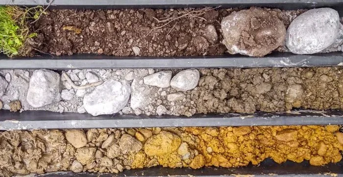
Stratigraphic Test Pits with Geotechnical Logging
Backhoe-excavated pits logged in detail by a senior geotechnical engineer. We document layer boundaries, moisture conditions, consistency, structure, and the bedrock weathering profile using the ASTM D2488 descriptive system. Digital photographs with scale reference are included in every report.
Foundation Verification and Bearing Surface Inspection
Pits advanced to the proposed footing elevation to confirm bearing stratum competency. We perform hand penetrometer and pocket shear vane tests on exposed surfaces, correlate results with laboratory strength testing, and certify that the bearing surface meets the design assumptions of the geotechnical report.
Frequently asked questions
What is the cost range for an exploratory test pit investigation in Guelph?
How do you ensure trench safety during test pit excavation in Guelph?
All excavations comply with Ontario Regulation 213/91. Pits deeper than 1.2 meters are either benched at a 1:1 slope, shored with hydraulic trench boxes, or stepped back depending on the soil type and groundwater conditions. The site-specific safety plan is prepared by a competent person and reviewed with the excavation contractor before breaking ground.
What information does a test pit provide that a borehole cannot?
A test pit exposes a continuous vertical face, allowing direct measurement of fracture orientation, weathering gradation, cobble and boulder frequency, and the true geometry of the soil-rock interface. Boreholes provide point data at discrete intervals; a test pit reveals lateral continuity and structural features that govern seepage and bearing capacity but are easily missed by drilling tools.
How deep can you excavate a test pit in the Guelph dolostone?
Practical depth is limited by equipment reach and trench safety requirements rather than material hardness. In weathered Guelph Formation dolostone, a standard backhoe can typically advance 0.5 to 1.0 meters into rock before production slows significantly. For deeper rock profiling beyond 4.5 meters total depth, we transition to coring methods and correlate the core log with the upper weathered profile documented in the pit.